Make a donation
Gear up for your next adventure:
As an Amazon Associate, this site earns from qualifying purchases at no extra cost to you.
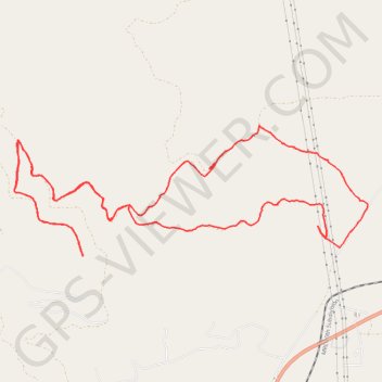
Bike ride on the slopes of Charity Peak
Morning Ride
- Distance: 10.2 mi
- Elevation gain: 565 m
- Maximum elevation: 1,556 m
- Elevation loss: 565 m
- Minimum elevation: 1,158 m
- Moving time: 1 h 33 m
- Moving speed: 6.5 mph
- Maximum speed: 45.2 mph
- Total time: 1 h 46 m
- Global speed: 5.7 mph
Interactive trail map
Make a donation
Gear up for your next adventure:
As an Amazon Associate, this site earns from qualifying purchases at no extra cost to you.
Trail profile
- Distance: 10.2 mi
- Elevation gain: 565 m
- Maximum elevation: 1,556 m
- Elevation loss: 565 m
- Minimum elevation: 1,158 m
- Moving time: 1 h 33 m
- Moving speed: 6.5 mph
- Maximum speed: 45.2 mph
- Total time: 1 h 46 m
- Global speed: 5.7 mph
Make a donation
Gear up for your next adventure:
As an Amazon Associate, this site earns from qualifying purchases at no extra cost to you.
About this trail
Name: Bike ride on the slopes of Charity Peak trail, distance, elevation, map, profile, GPS track
Start: 23580, Doney Lane, Schley, Missoula County, Montana, 59821, United States (47.07954 -114.06340)
End: 23580, Doney Lane, Schley, Missoula County, Montana, 59821, United States (47.07954 -114.06348)
Coordinates: 47.07862 -114.11145 47.09172 -114.05933
Make a donation
Gear up for your next adventure:
As an Amazon Associate, this site earns from qualifying purchases at no extra cost to you.
Other hiking, mountain biking, running and outdoor activity trails
Click on a trail to view its statistics, map and profile.
Charity peak area arlee to above frenchtown area
United States > Montana > Missoula County
Distance: 27.2 mi • Elevation gain: 1,258 m • Maximum elevation: 1,889 m
Morning Mountain Bike Ride
United States > Montana > Missoula County > Schley
Distance: 13.0 mi • Elevation gain: 383 m • Maximum elevation: 1,237 m
Schley
United States > Montana > Missoula County
Distance: 8.0 mi • Elevation gain: 261 m • Maximum elevation: 1,350 m