Thank you for supporting this site ❤️
Make a donation
Make a donation
Gear up for your next adventure:
As an Amazon Associate, this site earns from qualifying purchases at no extra cost to you.
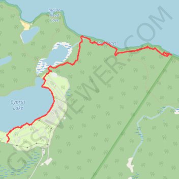
Bruce Peninsula National Park, Lake Huron, Cyprus Lake
Afternoon Hike
- Distance: 6.1 mi
- Elevation gain: 137 m
- Maximum elevation: 196 m
- Elevation loss: 136 m
- Minimum elevation: 174 m
- Moving time: 2 h 24 m
- Moving speed: 2.5 mph
- Maximum speed: 8.7 mph
- Total time: 3 h 37 m
- Global speed: 1.7 mph
Interactive trail map
Thank you for supporting this site ❤️
Make a donation
Make a donation
Gear up for your next adventure:
As an Amazon Associate, this site earns from qualifying purchases at no extra cost to you.
Trail profile
- Distance: 6.1 mi
- Elevation gain: 137 m
- Maximum elevation: 196 m
- Elevation loss: 136 m
- Minimum elevation: 174 m
- Moving time: 2 h 24 m
- Moving speed: 2.5 mph
- Maximum speed: 8.7 mph
- Total time: 3 h 37 m
- Global speed: 1.7 mph
Thank you for supporting this site ❤️
Make a donation
Make a donation
Gear up for your next adventure:
As an Amazon Associate, this site earns from qualifying purchases at no extra cost to you.
About this trail
Name: Bruce Peninsula National Park, Lake Huron, Cyprus Lake trail, distance, elevation, map, profile, GPS track
Coordinates: 45.22668 -81.53236 45.24206 -81.49832
Thank you for supporting this site ❤️
Make a donation
Make a donation
Gear up for your next adventure:
As an Amazon Associate, this site earns from qualifying purchases at no extra cost to you.
Other hiking, mountain biking, running and outdoor activity trails
Click on a trail to view its statistics, map and profile.
Bruce Peninsula National Park
Canada > Ontario > Bruce County
Lake Huron. #Hiking #Loop #Huron #BrucePeninsula
Distance: 3.7 mi • Elevation gain: 66 m • Maximum elevation: 197 m