Bruce Peninsula National Park
Lake Huron. #Hiking #Loop #Huron #BrucePeninsula
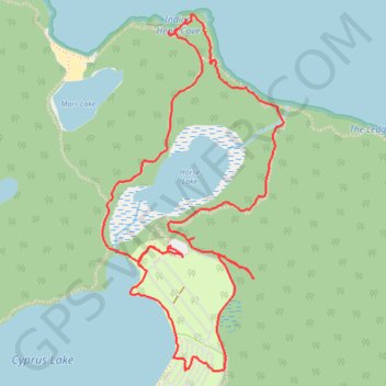
- Distance: 3.7 mi
- Elevation gain: 66 m
- Maximum elevation: 197 m
- Elevation loss: 66 m
- Minimum elevation: 174 m
Interactive trail map
Trail profile
- Distance: 3.7 mi
- Elevation gain: 66 m
- Maximum elevation: 197 m
- Elevation loss: 66 m
- Minimum elevation: 174 m
About this trail
Name: Bruce Peninsula National Park trail, distance, elevation, map, profile, GPS track
Coordinates: 45.23171 -81.52674 45.24557 -81.51674
Other hiking, mountain biking, running and outdoor activity trails
Click on a trail to view its statistics, map and profile.
Bruce Peninsula National Park, Lake Huron, Cyprus Lake
Canada > Ontario > Bruce County
Afternoon Hike
Distance: 6.1 mi • Elevation gain: 137 m • Maximum elevation: 196 m