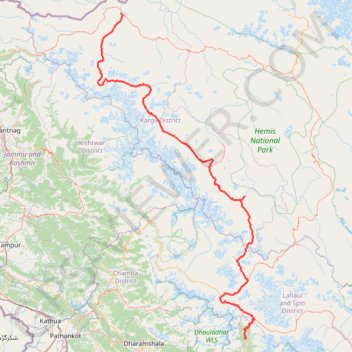
Manali - Kargil
Interactive trail map
Trail profile
- Distance: 327.6 mi
- Elevation gain: 11,632 m
- Maximum elevation: 5,038 m
- Elevation loss: 10,974 m
- Minimum elevation: 1,903 m
About this trail
Name: Manali - Kargil trail, distance, elevation, map, profile, GPS track
Coordinates: 32.24578 75.92972 34.55897 77.26204
Other hiking, mountain biking, running and outdoor activity trails
Click on a trail to view its statistics, map and profile.
Markha Valley - Hemis National Park
Distance: 58.3 mi • Elevation gain: 4,575 m • Maximum elevation: 5,265 m
Galu Devi temple - Triund Hill
India > Himachal Pradesh > Dharamshala > Haini > Galu Devi
Distance: 5.0 mi • Elevation gain: 1,367 m • Maximum elevation: 3,234 m
Ladhak Trek
India > Himachal Pradesh > Lahul > Darcha
Darcha, Panjilla, Chilling. #Hiking
Distance: 212.7 mi • Elevation gain: 14,524 m • Maximum elevation: 5,043 m