Make a donation
Gear up for your next adventure:
As an Amazon Associate, this site earns from qualifying purchases at no extra cost to you.
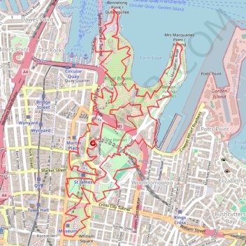
Royal Botanic Park - Sydney
Interactive trail map
Make a donation
Gear up for your next adventure:
As an Amazon Associate, this site earns from qualifying purchases at no extra cost to you.
Trail profile
- Distance: 8.8 mi
- Elevation gain: 399 m
- Maximum elevation: 68 m
- Elevation loss: 401 m
- Minimum elevation: -3 m
Make a donation
Gear up for your next adventure:
As an Amazon Associate, this site earns from qualifying purchases at no extra cost to you.
About this trail
Name: Royal Botanic Park - Sydney trail, distance, elevation, map, profile, GPS track
Coordinates: -33.87674 151.20965 -33.85631 151.22254
Make a donation
Gear up for your next adventure:
As an Amazon Associate, this site earns from qualifying purchases at no extra cost to you.
Other hiking, mountain biking, running and outdoor activity trails
Click on a trail to view its statistics, map and profile.
Centennial Park - Sydney
Australia > New South Wales > Sydney
#Bike #Centennial #Sydney
Distance: 18.3 mi • Elevation gain: 272 m • Maximum elevation: 74 m
Sydney to Oran Park NSW
Australia > New South Wales > Sydney
Distance: 37.5 mi • Elevation gain: 577 m • Maximum elevation: 126 m
Make a donation
Gear up for your next adventure:
As an Amazon Associate, this site earns from qualifying purchases at no extra cost to you.