Make a donation
Gear up for your next adventure:
As an Amazon Associate, this site earns from qualifying purchases at no extra cost to you.
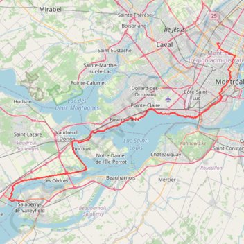
Salaberry-de-Valleyfield - Montréal
#Bike
- Distance: 55.9 mi
- Elevation gain: 363 m
- Maximum elevation: 70 m
- Elevation loss: 364 m
- Minimum elevation: 17 m
Interactive trail map
Make a donation
Gear up for your next adventure:
As an Amazon Associate, this site earns from qualifying purchases at no extra cost to you.
Trail profile
- Distance: 55.9 mi
- Elevation gain: 363 m
- Maximum elevation: 70 m
- Elevation loss: 364 m
- Minimum elevation: 17 m
Make a donation
Gear up for your next adventure:
As an Amazon Associate, this site earns from qualifying purchases at no extra cost to you.
About this trail
Name: Salaberry-de-Valleyfield - Montréal trail, distance, elevation, map, profile, GPS track
Coordinates: 45.26687 -74.18734 45.57900 -73.55446
Make a donation
Gear up for your next adventure:
As an Amazon Associate, this site earns from qualifying purchases at no extra cost to you.
Other hiking, mountain biking, running and outdoor activity trails
Click on a trail to view its statistics, map and profile.
Pierreville - Leclercville
Canada > Quebec > Urban agglomeration of Montreal > Montreal
#Bike #Pierreville #Leclercville #Atlantic
Distance: 75.1 mi • Elevation gain: 324 m • Maximum elevation: 36 m
Make a donation
Gear up for your next adventure:
As an Amazon Associate, this site earns from qualifying purchases at no extra cost to you.
East Hawkesbury - Montréal
Canada > Ontario > Prescott and Russell Counties > East Hawkesbury
#Bike #EastHawkesbury #Montréal
Distance: 56.8 mi • Elevation gain: 393 m • Maximum elevation: 91 m
Make a donation
Gear up for your next adventure:
As an Amazon Associate, this site earns from qualifying purchases at no extra cost to you.
Montréal - Lanoraie
Canada > Quebec > Urban agglomeration of Montreal > Montreal
Saint Lawrence River. #Bike #Montréal #Lanoraie #SaintLawrence
Distance: 43.6 mi • Elevation gain: 181 m • Maximum elevation: 52 m
Arboretum Morgan Yellow Trail
Canada > Quebec > Urban agglomeration of Montreal > Sainte-Anne-de-Bellevue
#Hiking #Snowshoeing #Ski
Distance: 2.8 mi • Elevation gain: 33 m • Maximum elevation: 56 m