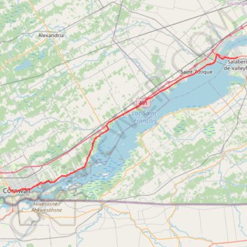
Cornwall - Salaberry-de-Valleyfield
#Bike
- Distance: 40.0 mi
- Elevation gain: 144 m
- Maximum elevation: 64 m
- Elevation loss: 154 m
- Minimum elevation: 44 m
Interactive trail map
Trail profile
- Distance: 40.0 mi
- Elevation gain: 144 m
- Maximum elevation: 64 m
- Elevation loss: 154 m
- Minimum elevation: 44 m
About this trail
Name: Cornwall - Salaberry-de-Valleyfield trail, distance, elevation, map, profile, GPS track
Coordinates: 45.01443 -74.74848 45.27497 -74.13727
Other hiking, mountain biking, running and outdoor activity trails
Click on a trail to view its statistics, map and profile.
Brockville - Lancaster
Canada > Ontario > Brockville > Brockville
Saint-Laurent River. #Bike #SaintLaurent
Distance: 84.1 mi • Elevation gain: 489 m • Maximum elevation: 101 m
Salaberry-de-Valleyfield - Montréal
Canada > Quebec > Beauharnois-Salaberry > Salaberry-de-Valleyfield
#Bike
Distance: 55.9 mi • Elevation gain: 363 m • Maximum elevation: 70 m
Cornwall Bike Path Loop
Canada > Ontario > Cornwall > Cornwall
Distance: 18.8 mi • Elevation gain: 154 m • Maximum elevation: 69 m
Cornwall Cycling
Canada > Ontario > Cornwall > Cornwall
Distance: 35.6 mi • Elevation gain: 333 m • Maximum elevation: 88 m