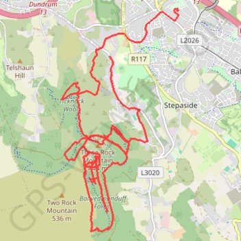
Ticknock MTB trails and hidden forest tracks
Mountain Bike Ride Ticknock
- Distance: 14.5 mi
- Elevation gain: 803 m
- Maximum elevation: 489 m
- Elevation loss: 851 m
- Minimum elevation: 120 m
- Moving time: 3 h 17 m
- Moving speed: 4.4 mph
- Maximum speed: 23.9 mph
- Total time: 4 h 13 m
- Global speed: 3.4 mph
Interactive trail map
Trail profile
- Distance: 14.5 mi
- Elevation gain: 803 m
- Maximum elevation: 489 m
- Elevation loss: 851 m
- Minimum elevation: 120 m
- Moving time: 3 h 17 m
- Moving speed: 4.4 mph
- Maximum speed: 23.9 mph
- Total time: 4 h 13 m
- Global speed: 3.4 mph
About this trail
Name: Ticknock MTB trails and hidden forest tracks trail, distance, elevation, map, profile, GPS track
Coordinates: 53.23355 -6.24500 53.26791 -6.21485
Other hiking, mountain biking, running and outdoor activity trails
Click on a trail to view its statistics, map and profile.
Ballycorus leadmines mtb trails brush clearing
Ireland > County Dublin > Sandyford
Afternoon Mountain Bike Ride thinning brush clearing lower leadmines, opened up 2 old trails lower woods close to Rathmichael.
Distance: 16.0 mi • Elevation gain: 445 m • Maximum elevation: 250 m
Two Rock Mountain and Three Rock Mountain Loop
Distance: 5.3 mi • Elevation gain: 286 m • Maximum elevation: 532 m
Three Rock Mountain Bike
3Rock MTB
Distance: 6.4 mi • Elevation gain: 288 m • Maximum elevation: 480 m
Three Rock Mountain Loop
3Rock MTB
Distance: 8.3 mi • Elevation gain: 446 m • Maximum elevation: 479 m
Three Rock Mountain MTB
Distance: 9.3 mi • Elevation gain: 465 m • Maximum elevation: 479 m
3Rock Loop MTB
Distance: 6.0 mi • Elevation gain: 321 m • Maximum elevation: 469 m
3Rock MTB
Three Rock Mountain
Distance: 8.4 mi • Elevation gain: 398 m • Maximum elevation: 479 m
Route1495
Ireland > County Dublin > Shankill
Distance: 24.1 mi • Elevation gain: 949 m • Maximum elevation: 531 m