Ballycorus leadmines mtb trails brush clearing
Afternoon Mountain Bike Ride thinning brush clearing lower leadmines, opened up 2 old trails lower woods close to Rathmichael.
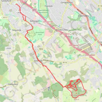
- Distance: 16.0 mi
- Elevation gain: 445 m
- Maximum elevation: 250 m
- Elevation loss: 444 m
- Minimum elevation: 92 m
- Moving time: 2 h 39 m
- Moving speed: 6.0 mph
- Maximum speed: 25.6 mph
- Total time: 5 h 21 m
- Global speed: 3.0 mph
Interactive trail map
Trail profile
- Distance: 16.0 mi
- Elevation gain: 445 m
- Maximum elevation: 250 m
- Elevation loss: 444 m
- Minimum elevation: 92 m
- Moving time: 2 h 39 m
- Moving speed: 6.0 mph
- Maximum speed: 25.6 mph
- Total time: 5 h 21 m
- Global speed: 3.0 mph
About this trail
Name: Ballycorus leadmines mtb trails brush clearing trail, distance, elevation, map, profile, GPS track
Coordinates: 53.21413 -6.21520 53.26807 -6.14797
Other hiking, mountain biking, running and outdoor activity trails
Click on a trail to view its statistics, map and profile.
Ticknock MTB trails and hidden forest tracks
Ireland > County Dublin > Sandyford
Mountain Bike Ride Ticknock
Distance: 14.5 mi • Elevation gain: 803 m • Maximum elevation: 489 m
Carrickgollogan Wood loop
Distance: 2.1 mi • Elevation gain: 99 m • Maximum elevation: 247 m
Route1495
Ireland > County Dublin > Shankill
Distance: 24.1 mi • Elevation gain: 949 m • Maximum elevation: 531 m