Mount Edgcumbe
- Distance: 8.9 mi
- Elevation gain: 348 m
- Maximum elevation: 91 m
- Elevation loss: 390 m
- Minimum elevation: -1 m
Interactive trail map
Trail profile
- Distance: 8.9 mi
- Elevation gain: 348 m
- Maximum elevation: 91 m
- Elevation loss: 390 m
- Minimum elevation: -1 m
About this trail
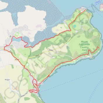
Name: Mount Edgcumbe trail, distance, elevation, map, profile, GPS track
Start: Admiralty Road, Stonehouse, Plymouth, England, PL1 3RS, United Kingdom (50.34658 -4.16764)
Coordinates: 50.33092 -4.21979 50.35995 -4.16757
Topography: Plymouth topographic map, elevation, terrain
Other hiking, mountain biking, running and outdoor activity trails
Click on a trail to view its statistics, map and profile.
Loop Walk from Cawsand, Cornwall
United Kingdom > England > Cornwall > Cawsand
Distance: 3.9 mi • Elevation gain: 188 m • Maximum elevation: 107 m
Cawsand, Anthony, Torpoint
United Kingdom > England > Cornwall > Cawsand
Distance: 10.1 mi • Elevation gain: 397 m • Maximum elevation: 113 m