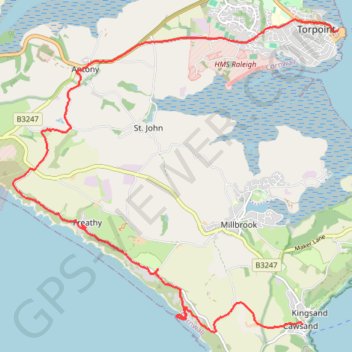
Cawsand, Anthony, Torpoint
- Distance: 10.1 mi
- Elevation gain: 397 m
- Maximum elevation: 113 m
- Elevation loss: 422 m
- Minimum elevation: 0 m
Interactive trail map
Trail profile
- Distance: 10.1 mi
- Elevation gain: 397 m
- Maximum elevation: 113 m
- Elevation loss: 422 m
- Minimum elevation: 0 m
About this trail
Name: Cawsand, Anthony, Torpoint trail, distance, elevation, map, profile, GPS track
Start: New Road, Maker-with-Rame, Cawsand, Cornwall, England, PL10 1PL, United Kingdom (50.33256 -4.20209)
End: Tamar Street, Torpoint, Cornwall, England, PL11 2AH, United Kingdom (50.37548 -4.19388)
Coordinates: 50.33138 -4.26847 50.37712 -4.19388
Topography: Cornwall topographic map, elevation, terrain
Other hiking, mountain biking, running and outdoor activity trails
Click on a trail to view its statistics, map and profile.
Loop Walk from Cawsand, Cornwall
United Kingdom > England > Cornwall > Cawsand
Distance: 3.9 mi • Elevation gain: 188 m • Maximum elevation: 107 m
Mount Edgcumbe
United Kingdom > England > Plymouth
Distance: 8.9 mi • Elevation gain: 348 m • Maximum elevation: 91 m