2024-05-03 16:11:23
- Distance: 5.6 mi
- Elevation gain: 611 m
- Maximum elevation: 756 m
- Elevation loss: 611 m
- Minimum elevation: 155 m
- Moving time: 3 h 4 m
- Moving speed: 1.8 mph
- Maximum speed: 3.8 mph
- Total time: 4 h 19 m
- Global speed: 1.3 mph
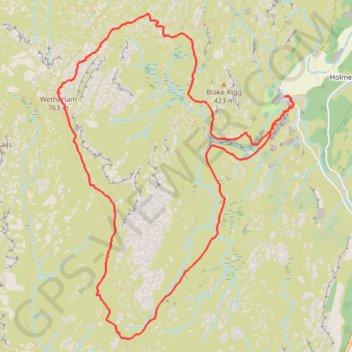
Interactive trail map
Trail profile
- Distance: 5.6 mi
- Elevation gain: 611 m
- Maximum elevation: 756 m
- Elevation loss: 611 m
- Minimum elevation: 155 m
- Moving time: 3 h 4 m
- Moving speed: 1.8 mph
- Maximum speed: 3.8 mph
- Total time: 4 h 19 m
- Global speed: 1.3 mph
About this trail
Name: 2024-05-03 16:11:23 trail, distance, elevation, map, profile, GPS track
Coordinates: 54.38326 -3.09801 54.40595 -3.06983
Topography: Westmorland and Furness topographic map, elevation, terrain
Other hiking, mountain biking, running and outdoor activity trails
Click on a trail to view its statistics, map and profile.
Sun Coniston to Great Langdale
United Kingdom > England > Westmorland and Furness > Coniston
Distance: 9.1 mi • Elevation gain: 999 m • Maximum elevation: 796 m