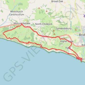
Charmouth to West Bay via Golden Cap, Seatown Beach, Thorncombe Beacon and Eype Beach
- Distance: 14.2 mi
- Elevation gain: 768 m
- Maximum elevation: 172 m
- Elevation loss: 767 m
- Minimum elevation: -1 m
- Moving time: 6 h 6 m
- Moving speed: 2.3 mph
- Maximum speed: 3.8 mph
- Total time: 7 h 12 m
- Global speed: 2.0 mph
Interactive trail map
Trail profile
- Distance: 14.2 mi
- Elevation gain: 768 m
- Maximum elevation: 172 m
- Elevation loss: 767 m
- Minimum elevation: -1 m
- Moving time: 6 h 6 m
- Moving speed: 2.3 mph
- Maximum speed: 3.8 mph
- Total time: 7 h 12 m
- Global speed: 2.0 mph
About this trail
Name: Charmouth to West Bay via Golden Cap, Seatown Beach, Thorncombe Beacon and Eype Beach trail, distance, elevation, map, profile, GPS track
Coordinates: 50.70878 -2.87825 50.74407 -2.76353
Topography: Dorset topographic map, elevation, terrain
Other hiking, mountain biking, running and outdoor activity trails
Click on a trail to view its statistics, map and profile.
Loop between West Bay and West Bexington along Lyme Bay
United Kingdom > England > Dorset > Bridport
Distance: 13.7 mi • Elevation gain: 299 m • Maximum elevation: 128 m
Lyme Regis Charmouth
United Kingdom > England > Dorset > Lyme Regis
Dorset National Landscape
Distance: 14.7 mi • Elevation gain: 796 m • Maximum elevation: 174 m