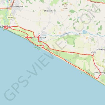
Loop between West Bay and West Bexington along Lyme Bay
- Distance: 13.7 mi
- Elevation gain: 299 m
- Maximum elevation: 128 m
- Elevation loss: 297 m
- Minimum elevation: -1 m
- Moving time: 5 h 27 m
- Moving speed: 2.5 mph
- Maximum speed: 3.7 mph
- Total time: 6 h 35 m
- Global speed: 2.1 mph
Interactive trail map
Trail profile
- Distance: 13.7 mi
- Elevation gain: 299 m
- Maximum elevation: 128 m
- Elevation loss: 297 m
- Minimum elevation: -1 m
- Moving time: 5 h 27 m
- Moving speed: 2.5 mph
- Maximum speed: 3.7 mph
- Total time: 6 h 35 m
- Global speed: 2.1 mph
About this trail
Name: Loop between West Bay and West Bexington along Lyme Bay trail, distance, elevation, map, profile, GPS track
End: Burton Road, Burton Bradstock, Dorset, England, DT6 4PT, United Kingdom (50.71077 -2.74739)
Coordinates: 50.67573 -2.76389 50.71154 -2.66128
Topography: Dorset topographic map, elevation, terrain
Other hiking, mountain biking, running and outdoor activity trails
Click on a trail to view its statistics, map and profile.
Charmouth to West Bay via Golden Cap, Seatown Beach, Thorncombe Beacon and Eype Beach
United Kingdom > England > Dorset
Distance: 14.2 mi • Elevation gain: 768 m • Maximum elevation: 172 m
West Bexington to Portisham Loop
United Kingdom > England > Dorset > West Bexington
Distance: 13.3 mi • Elevation gain: 352 m • Maximum elevation: 184 m