Make a donation
Gear up for your next adventure:
As an Amazon Associate, this site earns from qualifying purchases at no extra cost to you.
灣篤14號坑 望東坑右源 大灣右坑 田字坑左源 企角坑
Hong Kong Hike
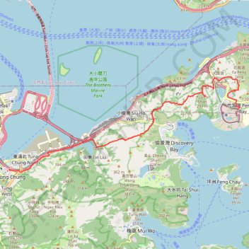
- Distance: 11.3 mi
- Elevation gain: 960 m
- Maximum elevation: 343 m
- Elevation loss: 949 m
- Minimum elevation: -2 m
- Moving time: 4 h 57 m
- Moving speed: 2.3 mph
- Maximum speed: 16.8 mph
- Total time: 8 h 29 m
- Global speed: 1.3 mph
Interactive trail map
Make a donation
Gear up for your next adventure:
As an Amazon Associate, this site earns from qualifying purchases at no extra cost to you.
Trail profile
- Distance: 11.3 mi
- Elevation gain: 960 m
- Maximum elevation: 343 m
- Elevation loss: 949 m
- Minimum elevation: -2 m
- Moving time: 4 h 57 m
- Moving speed: 2.3 mph
- Maximum speed: 16.8 mph
- Total time: 8 h 29 m
- Global speed: 1.3 mph
Make a donation
Gear up for your next adventure:
As an Amazon Associate, this site earns from qualifying purchases at no extra cost to you.
About this trail
Name: 灣篤14號坑 望東坑右源 大灣右坑 田字坑左源 企角坑 trail, distance, elevation, map, profile, GPS track
Coordinates: 22.28854 113.94226 22.32822 114.04579
Make a donation
Gear up for your next adventure:
As an Amazon Associate, this site earns from qualifying purchases at no extra cost to you.
Other hiking, mountain biking, running and outdoor activity trails
Click on a trail to view its statistics, map and profile.
2024 4TUL Half Loop Final
China > Hong Kong > Tsuen Wan District > Chuen Lung Village > Chuen Lung Cha Tau Wo
Distance: 55.3 mi • Elevation gain: 2,267 m • Maximum elevation: 535 m
獅子頭南坑左 獅子頭坑 昂深下源 深石坑
China > Hong Kong > Islands District > Luk Wu
Islands District Hike
Distance: 9.5 mi • Elevation gain: 590 m • Maximum elevation: 311 m