14-MAI-12 AUMONT AUBRAC-NASBINALS
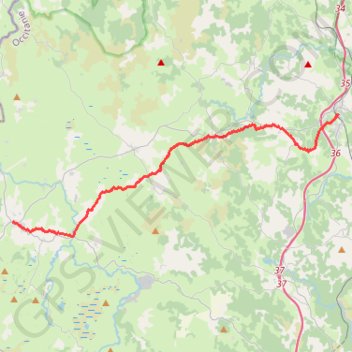
Via Podiensis GR65 Aumont Aubrac-Nasbinals
- Distance: 16.2 mi
- Elevation gain: 523 m
- Maximum elevation: 1,259 m
- Elevation loss: 396 m
- Minimum elevation: 1,015 m
- Moving time: 6 h 47 m
- Moving speed: 2.4 mph
- Maximum speed: 3.4 mph
- Total time: 22 h 1 m
- Global speed: 0.7 mph
Interactive trail map
Trail profile
- Distance: 16.2 mi
- Elevation gain: 523 m
- Maximum elevation: 1,259 m
- Elevation loss: 396 m
- Minimum elevation: 1,015 m
- Moving time: 6 h 47 m
- Moving speed: 2.4 mph
- Maximum speed: 3.4 mph
- Total time: 22 h 1 m
- Global speed: 0.7 mph
About this trail
Name: 14-MAI-12 AUMONT AUBRAC-NASBINALS trail, distance, elevation, map, profile, GPS track
Coordinates: 44.65472 3.04593 44.71846 3.28458
Other hiking, mountain biking, running and outdoor activity trails
Click on a trail to view its statistics, map and profile.
PT23DS2 Lörrach → Cadaqués
Germany > Baden-Württemberg > Landkreis Lörrach > Lörrach (Kernstadt)
Distance: 652.9 mi • Elevation gain: 13,130 m • Maximum elevation: 1,505 m
Southern section — European Divide Trail
France > Auvergne-Rhône-Alpes > Drôme > Valence
Distance: 1,506.1 mi • Elevation gain: 42,375 m • Maximum elevation: 2,005 m
Chemin de Saint-Jacques-de-Compostelle
Switzerland > Geneva > Geneva
Distance: 694.6 mi • Elevation gain: 25,262 m • Maximum elevation: 1,430 m