Make a donation
Gear up for your next adventure:
As an Amazon Associate, this site earns from qualifying purchases at no extra cost to you.
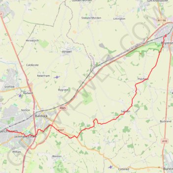
From Royston to Letchworth
- Distance: 14.7 mi
- Elevation gain: 260 m
- Maximum elevation: 168 m
- Elevation loss: 234 m
- Minimum elevation: 58 m
- Moving time: 5 h 34 m
- Moving speed: 2.6 mph
- Maximum speed: 3.7 mph
- Total time: 6 h 20 m
- Global speed: 2.3 mph
Interactive trail map
Make a donation
Gear up for your next adventure:
As an Amazon Associate, this site earns from qualifying purchases at no extra cost to you.
Trail profile
- Distance: 14.7 mi
- Elevation gain: 260 m
- Maximum elevation: 168 m
- Elevation loss: 234 m
- Minimum elevation: 58 m
- Moving time: 5 h 34 m
- Moving speed: 2.6 mph
- Maximum speed: 3.7 mph
- Total time: 6 h 20 m
- Global speed: 2.3 mph
Make a donation
Gear up for your next adventure:
As an Amazon Associate, this site earns from qualifying purchases at no extra cost to you.
About this trail
Name: From Royston to Letchworth trail, distance, elevation, map, profile, GPS track
Coordinates: 51.97090 -0.23335 52.05355 -0.02562
Topography: North Hertfordshire topographic map, elevation, terrain
Make a donation
Gear up for your next adventure:
As an Amazon Associate, this site earns from qualifying purchases at no extra cost to you.
Other hiking, mountain biking, running and outdoor activity trails
Click on a trail to view its statistics, map and profile.
Letchworth Greenway
United Kingdom > England > Hertfordshire > North Hertfordshire > Willian
Route created on plotaroute.com
Distance: 12.8 mi • Elevation gain: 161 m • Maximum elevation: 108 m
Deacon Hill
United Kingdom > England > Hertfordshire > North Hertfordshire
Letchworth, Ickleford, Pirton, Deacon Hill and return
Distance: 16.4 mi • Elevation gain: 293 m • Maximum elevation: 182 m
Circuit from Baldock
United Kingdom > England > Hertfordshire > North Hertfordshire > Baldock
Distance: 12.6 mi • Elevation gain: 202 m • Maximum elevation: 149 m