Bike ride to Payson and back
payson, paved, bike, trail, backroads
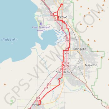
- Distance: 44.0 mi
- Elevation gain: 230 m
- Maximum elevation: 1,428 m
- Elevation loss: 230 m
- Minimum elevation: 1,370 m
Interactive trail map
Trail profile
- Distance: 44.0 mi
- Elevation gain: 230 m
- Maximum elevation: 1,428 m
- Elevation loss: 230 m
- Minimum elevation: 1,370 m
About this trail
Name: Bike ride to Payson and back trail, distance, elevation, map, profile, GPS track
Coordinates: 40.04359 -111.72550 40.26143 -111.63807
Other hiking, mountain biking, running and outdoor activity trails
Click on a trail to view its statistics, map and profile.
Right up to the Linden Temple and by Utah Lake
United States > Utah > Utah County > Provo > Pleasant View
Bonk ride to Lindon and by Utah Lake lake, lindon, utah, bike, paved
Distance: 23.0 mi • Elevation gain: 223 m • Maximum elevation: 1,487 m
Provo River, Utah Lake and back
United States > Utah > Utah County > Provo > Pleasant View
Distance: 11.3 mi • Elevation gain: 62 m • Maximum elevation: 1,417 m
Bike ride to Mapleton and back
United States > Utah > Utah County > Provo > Pleasant View
bike, paved, mapleton, utah
Distance: 35.1 mi • Elevation gain: 234 m • Maximum elevation: 1,480 m