Make a donation
Gear up for your next adventure:
As an Amazon Associate, this site earns from qualifying purchases at no extra cost to you.
Right up to the Linden Temple and by Utah Lake
Bonk ride to Lindon and by Utah Lake
lake, lindon, utah, bike, paved
- Distance: 23.0 mi
- Elevation gain: 223 m
- Maximum elevation: 1,487 m
- Elevation loss: 223 m
- Minimum elevation: 1,371 m
Interactive trail map
Make a donation
Gear up for your next adventure:
As an Amazon Associate, this site earns from qualifying purchases at no extra cost to you.
Trail profile
- Distance: 23.0 mi
- Elevation gain: 223 m
- Maximum elevation: 1,487 m
- Elevation loss: 223 m
- Minimum elevation: 1,371 m
Make a donation
Gear up for your next adventure:
As an Amazon Associate, this site earns from qualifying purchases at no extra cost to you.
About this trail
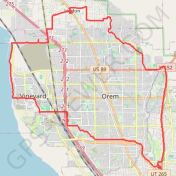
Name: Right up to the Linden Temple and by Utah Lake trail, distance, elevation, map, profile, GPS track
Coordinates: 40.25957 -111.76437 40.34544 -111.65551
Make a donation
Gear up for your next adventure:
As an Amazon Associate, this site earns from qualifying purchases at no extra cost to you.
Other hiking, mountain biking, running and outdoor activity trails
Click on a trail to view its statistics, map and profile.
Ride up to Bridal Veil Falls
United States > Utah > Utah County > Provo > Pleasant View
Distance: 14.9 mi • Elevation gain: 252 m • Maximum elevation: 1,566 m
Provo River, Utah Lake and back
United States > Utah > Utah County > Provo > Pleasant View
Distance: 11.3 mi • Elevation gain: 62 m • Maximum elevation: 1,417 m
Bike ride to Mapleton and back
United States > Utah > Utah County > Provo > Pleasant View
bike, paved, mapleton, utah
Distance: 35.1 mi • Elevation gain: 234 m • Maximum elevation: 1,480 m
Bike ride to Payson and back
United States > Utah > Utah County > Provo > Pleasant View
payson, paved, bike, trail, backroads
Distance: 44.0 mi • Elevation gain: 230 m • Maximum elevation: 1,428 m
Make a donation
Gear up for your next adventure:
As an Amazon Associate, this site earns from qualifying purchases at no extra cost to you.