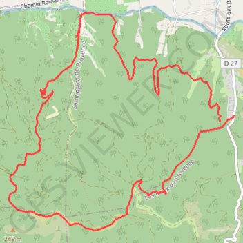
La Lèque
- Distance: 6.6 mi
- Elevation gain: 294 m
- Maximum elevation: 230 m
- Elevation loss: 278 m
- Minimum elevation: 57 m
Interactive trail map
Trail profile
- Distance: 6.6 mi
- Elevation gain: 294 m
- Maximum elevation: 230 m
- Elevation loss: 278 m
- Minimum elevation: 57 m
About this trail
Name: La Lèque trail, distance, elevation, map, profile, GPS track
Coordinates: 43.75873 4.76257 43.78063 4.79386
Other hiking, mountain biking, running and outdoor activity trails
Click on a trail to view its statistics, map and profile.
1 LUCENA - MONTPELLIER
Distance: 1,842.0 mi • Elevation gain: 29,500 m • Maximum elevation: 1,048 m
PT23DS2 Lörrach → Cadaqués
Germany > Baden-Württemberg > Landkreis Lörrach > Lörrach (Kernstadt)
Distance: 652.9 mi • Elevation gain: 13,130 m • Maximum elevation: 1,505 m
Southern section — European Divide Trail
France > Auvergne-Rhône-Alpes > Drôme > Valence
Distance: 1,506.1 mi • Elevation gain: 42,375 m • Maximum elevation: 2,005 m
Chemin de Saint-Jacques-de-Compostelle
Switzerland > Geneva > Geneva
Distance: 694.6 mi • Elevation gain: 25,262 m • Maximum elevation: 1,430 m