Make a donation
Gear up for your next adventure:
As an Amazon Associate, this site earns from qualifying purchases at no extra cost to you.
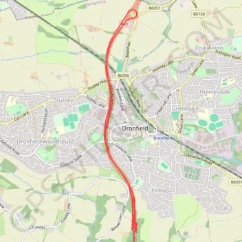
RE SK350770 3
- Distance: 6.0 mi
- Elevation gain: 95 m
- Maximum elevation: 195 m
- Elevation loss: 89 m
- Minimum elevation: 154 m
Interactive trail map
Make a donation
Gear up for your next adventure:
As an Amazon Associate, this site earns from qualifying purchases at no extra cost to you.
Trail profile
- Distance: 6.0 mi
- Elevation gain: 95 m
- Maximum elevation: 195 m
- Elevation loss: 89 m
- Minimum elevation: 154 m
Make a donation
Gear up for your next adventure:
As an Amazon Associate, this site earns from qualifying purchases at no extra cost to you.
About this trail
Name: RE SK350770 3 trail, distance, elevation, map, profile, GPS track
Coordinates: 53.28848 -1.48174 53.31727 -1.47472
Topography: North East Derbyshire topographic map, elevation, terrain
Make a donation
Gear up for your next adventure:
As an Amazon Associate, this site earns from qualifying purchases at no extra cost to you.
Other hiking, mountain biking, running and outdoor activity trails
Click on a trail to view its statistics, map and profile.
Gravel ride loop from Sheffield to Hornsea and York
United Kingdom > England > Sheffield
Distance: 207.1 mi • Elevation gain: 1,836 m • Maximum elevation: 222 m
RE SK350770
United Kingdom > England > Derbyshire > North East Derbyshire > Dronfield
Distance: 0.9 mi • Elevation gain: 14 m • Maximum elevation: 197 m