Thank you for supporting this site ❤️
Make a donation
Make a donation
Gear up for your next adventure:
As an Amazon Associate, this site earns from qualifying purchases at no extra cost to you.
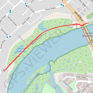
Baigup Wetlands Trail along Swan River
Walk
- Distance: 1.3 mi
- Elevation gain: 13 m
- Maximum elevation: 13 m
- Elevation loss: 14 m
- Minimum elevation: 2 m
- Moving time: 29 m 47 s
- Moving speed: 2.6 mph
- Maximum speed: 5.1 mph
- Total time: 31 m 17 s
- Global speed: 2.5 mph
Interactive trail map
Thank you for supporting this site ❤️
Make a donation
Make a donation
Gear up for your next adventure:
As an Amazon Associate, this site earns from qualifying purchases at no extra cost to you.
Trail profile
- Distance: 1.3 mi
- Elevation gain: 13 m
- Maximum elevation: 13 m
- Elevation loss: 14 m
- Minimum elevation: 2 m
- Moving time: 29 m 47 s
- Moving speed: 2.6 mph
- Maximum speed: 5.1 mph
- Total time: 31 m 17 s
- Global speed: 2.5 mph
Thank you for supporting this site ❤️
Make a donation
Make a donation
Gear up for your next adventure:
As an Amazon Associate, this site earns from qualifying purchases at no extra cost to you.
About this trail
Name: Baigup Wetlands Trail along Swan River trail, distance, elevation, map, profile, GPS track
Coordinates: -31.93556 115.90742 -31.93125 115.91659
Thank you for supporting this site ❤️
Make a donation
Make a donation
Gear up for your next adventure:
As an Amazon Associate, this site earns from qualifying purchases at no extra cost to you.
Other hiking, mountain biking, running and outdoor activity trails
Click on a trail to view its statistics, map and profile.
2021 Toodyay return via Kep
Distance: 142.9 mi • Elevation gain: 1,859 m • Maximum elevation: 357 m