Thank you for supporting this site ❤️
Make a donation
Make a donation
Gear up for your next adventure:
As an Amazon Associate, this site earns from qualifying purchases at no extra cost to you.
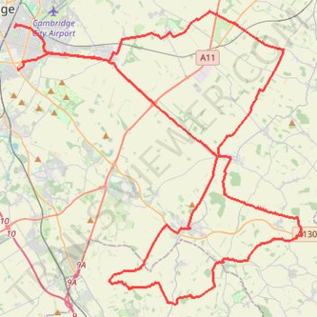
Gravel bike loop ride from Cambridge
- Distance: 45.1 mi
- Elevation gain: 637 m
- Maximum elevation: 118 m
- Elevation loss: 636 m
- Minimum elevation: 11 m
- Moving time: 4 h 19 m
- Moving speed: 10.4 mph
- Maximum speed: 28.3 mph
- Total time: 4 h 40 m
- Global speed: 9.7 mph
Interactive trail map
Thank you for supporting this site ❤️
Make a donation
Make a donation
Gear up for your next adventure:
As an Amazon Associate, this site earns from qualifying purchases at no extra cost to you.
Trail profile
- Distance: 45.1 mi
- Elevation gain: 637 m
- Maximum elevation: 118 m
- Elevation loss: 636 m
- Minimum elevation: 11 m
- Moving time: 4 h 19 m
- Moving speed: 10.4 mph
- Maximum speed: 28.3 mph
- Total time: 4 h 40 m
- Global speed: 9.7 mph
Thank you for supporting this site ❤️
Make a donation
Make a donation
Gear up for your next adventure:
As an Amazon Associate, this site earns from qualifying purchases at no extra cost to you.
About this trail
Name: Gravel bike loop ride from Cambridge trail, distance, elevation, map, profile, GPS track
Coordinates: 52.06065 0.14387 52.20393 0.37321
Topography: Cambridge topographic map, elevation, terrain
Thank you for supporting this site ❤️
Make a donation
Make a donation
Gear up for your next adventure:
As an Amazon Associate, this site earns from qualifying purchases at no extra cost to you.
Other hiking, mountain biking, running and outdoor activity trails
Click on a trail to view its statistics, map and profile.
Gog Coffee Loop Ride
United Kingdom > England > Cambridgeshire > Cambridge
Distance: 23.9 mi • Elevation gain: 191 m • Maximum elevation: 70 m