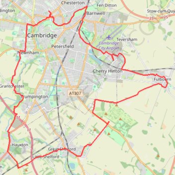
Gog Coffee Loop Ride
- Distance: 23.9 mi
- Elevation gain: 191 m
- Maximum elevation: 70 m
- Elevation loss: 191 m
- Minimum elevation: 7 m
- Moving time: 2 h 12 m
- Moving speed: 10.8 mph
- Maximum speed: 29.6 mph
- Total time: 2 h 53 m
- Global speed: 8.3 mph
Interactive trail map
Trail profile
- Distance: 23.9 mi
- Elevation gain: 191 m
- Maximum elevation: 70 m
- Elevation loss: 191 m
- Minimum elevation: 7 m
- Moving time: 2 h 12 m
- Moving speed: 10.8 mph
- Maximum speed: 29.6 mph
- Total time: 2 h 53 m
- Global speed: 8.3 mph
About this trail
Name: Gog Coffee Loop Ride trail, distance, elevation, map, profile, GPS track
Coordinates: 52.13682 0.08994 52.22009 0.22417
Topography: Cambridge topographic map, elevation, terrain
Other hiking, mountain biking, running and outdoor activity trails
Click on a trail to view its statistics, map and profile.
Gravel bike loop ride from Cambridge
United Kingdom > England > Cambridgeshire > Cambridge
Distance: 45.1 mi • Elevation gain: 637 m • Maximum elevation: 118 m
Cambridge
United Kingdom > England > Cambridgeshire > Cambridge
Distance: 6.0 mi • Elevation gain: 37 m • Maximum elevation: 21 m