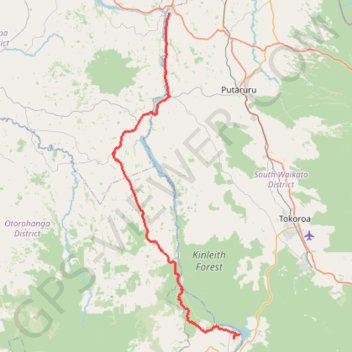
Import a GPX file

Piarere - Mangakino

Waikato River. #Bike #Road #Countryside #River #Lake #Forest #Nature

  • Distance: 42.0 mi
  • Elevation gain: 950 m
  • Maximum elevation: 396 m
  • Elevation loss: 843 m
  • Minimum elevation: 61 m

Interactive trail map

Trail profile

  • Distance: 42.0 mi
  • Elevation gain: 950 m
  • Maximum elevation: 396 m
  • Elevation loss: 843 m
  • Minimum elevation: 61 m

About this trail

Name: Piarere - Mangakino trail, distance, elevation, map, profile, GPS track

Start: Horahora Road, South Waikato District, Waikato, New Zealand (-37.95264 175.66614)

End: 44, Moana Crescent, Mangakino, Taupō District, Waikato, 3421, New Zealand (-38.36662 175.77765)

Coordinates: -38.37136 175.57301 -37.95264 175.78033

Other hiking, mountain biking, running and outdoor activity trails

Click on a trail to view its statistics, map and profile.

Mangakino - Piropiro

New Zealand > Waikato > Taupo District > Mangakino

#Bike #Maraetai #Waikato

Distance: 51.3 mi • Elevation gain: 1,893 m • Maximum elevation: 995 m

Gear up for your next adventure:

🗺️Topographic Maps - Detailed maps showing elevation and terrain features
🚶Walking Pedometers - Simple distance tracking for casual trail walkers
🧰Survival Kits - Emergency tools for remote environments
🔦LED Camping Lanterns - Illumination for reading maps inside your tent at night
🛌Insulated Sleeping Mats - Crucial thermal protection when sleeping on cold, uneven ground

As an Amazon Associate, this site earns from qualifying purchases at no extra cost to you.