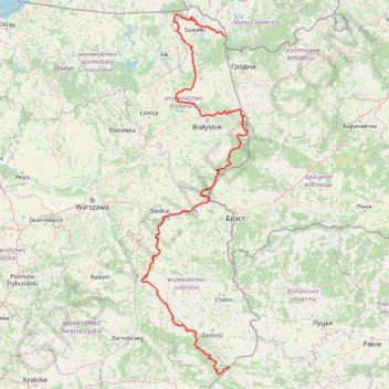
TET_PL-01_20220823
- Distance: 665.1 mi
- Elevation gain: 5,097 m
- Maximum elevation: 342 m
- Elevation loss: 4,976 m
- Minimum elevation: 104 m
Interactive trail map
Trail profile
- Distance: 665.1 mi
- Elevation gain: 5,097 m
- Maximum elevation: 342 m
- Elevation loss: 4,976 m
- Minimum elevation: 104 m
About this trail
Name: TET_PL-01_20220823 trail, distance, elevation, map, profile, GPS track
Start: Wigrańce, gmina Sejny, Sejny County, Podlaskie Voivodeship, Poland (54.06343 23.50056)
Coordinates: 50.19146 21.93294 54.31062 23.90840
Other hiking, mountain biking, running and outdoor activity trails
Click on a trail to view its statistics, map and profile.
20240728Bieg na dworze
Poland > Lublin Voivodeship > Lubartów County > Wandzin
Distance: 7.5 mi • Elevation gain: 73 m • Maximum elevation: 204 m