20240728Bieg na dworze
- Distance: 7.5 mi
- Elevation gain: 73 m
- Maximum elevation: 204 m
- Elevation loss: 73 m
- Minimum elevation: 177 m
- Moving time: 1 h 16 m
- Moving speed: 5.9 mph
- Maximum speed: 8.4 mph
- Total time: 1 h 16 m
- Global speed: 5.9 mph
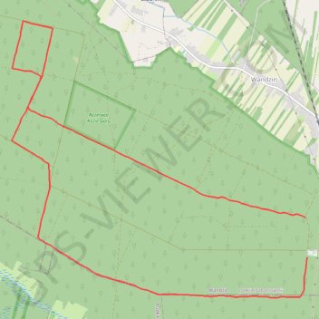
Interactive trail map
Trail profile
- Distance: 7.5 mi
- Elevation gain: 73 m
- Maximum elevation: 204 m
- Elevation loss: 73 m
- Minimum elevation: 177 m
- Moving time: 1 h 16 m
- Moving speed: 5.9 mph
- Maximum speed: 8.4 mph
- Total time: 1 h 16 m
- Global speed: 5.9 mph
About this trail
Name: 20240728Bieg na dworze trail, distance, elevation, map, profile, GPS track
Start: Wandzin, gmina Lubartów, Lubartów County, Lublin Voivodeship, Poland (51.38803 22.62777)
Coordinates: 51.37935 22.57673 51.40934 22.62800
Other hiking, mountain biking, running and outdoor activity trails
Click on a trail to view its statistics, map and profile.
TET_PL-01_20220823
Poland > Podlaskie Voivodeship > Sejny County > Wigrańce
Distance: 665.1 mi • Elevation gain: 5,097 m • Maximum elevation: 342 m