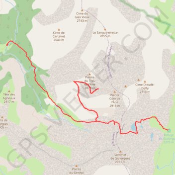
Col de la Roche Trouée
Randonnée pédestre. #Randonnée #Alpes #Montagne #Mercantour #Nature
- Distance: 6.5 mi
- Elevation gain: 925 m
- Maximum elevation: 2,848 m
- Elevation loss: 711 m
- Minimum elevation: 2,064 m
- Moving time: 4 h 7 m
- Moving speed: 1.6 mph
- Maximum speed: 6.1 mph
- Total time: 7 h 19 m
- Global speed: 0.9 mph
Interactive trail map
Trail profile
- Distance: 6.5 mi
- Elevation gain: 925 m
- Maximum elevation: 2,848 m
- Elevation loss: 711 m
- Minimum elevation: 2,064 m
- Moving time: 4 h 7 m
- Moving speed: 1.6 mph
- Maximum speed: 6.1 mph
- Total time: 7 h 19 m
- Global speed: 0.9 mph
About this trail
Name: Col de la Roche Trouée trail, distance, elevation, map, profile, GPS track
Coordinates: 44.23573 6.77365 44.25472 6.81970
Other hiking, mountain biking, running and outdoor activity trails
Click on a trail to view its statistics, map and profile.
1 LUCENA - MONTPELLIER
Distance: 1,842.0 mi • Elevation gain: 29,500 m • Maximum elevation: 1,048 m
PT23DS2 Lörrach → Cadaqués
Germany > Baden-Württemberg > Landkreis Lörrach > Lörrach (Kernstadt)
Distance: 652.9 mi • Elevation gain: 13,130 m • Maximum elevation: 1,505 m
Cime de Pal - Lacs de l'Estrop
France > Provence-Alpes-Côte d'Azur > Maritime Alps > Saint-Étienne-de-Tinée
Randonnée pédestre. #Randonnée #Alpes #Montagne #Mercantour #Nature
Distance: 7.2 mi • Elevation gain: 670 m • Maximum elevation: 2,798 m
GR 52 De Entraunes à Menton (Alpes-Maritimes) (2021)
France > Provence-Alpes-Côte d'Azur > Maritime Alps > Entraunes
Randonnée sur le GR 52 à travers les Alpes-Maritimes et le Parc National du Mercantour de Entraunes à Menton.
Distance: 138.5 mi • Elevation gain: 14,201 m • Maximum elevation: 2,713 m
Route des grandes alpes J4
France > Provence-Alpes-Côte d'Azur > Alpes-de-Haute-Provence > Jausiers > Guégnier
Distance: 110.3 mi • Elevation gain: 6,387 m • Maximum elevation: 2,806 m