Taabinga and Wattle Grove
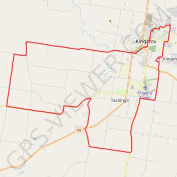
Kingaroy, Taabinga, Inverlaw, Wattle Grove
- Distance: 33.7 mi
- Elevation gain: 474 m
- Maximum elevation: 542 m
- Elevation loss: 474 m
- Minimum elevation: 409 m
- Moving time: 2 h 59 m
- Moving speed: 11.3 mph
- Maximum speed: 36.0 mph
- Total time: 3 h 26 m
- Global speed: 9.8 mph
Interactive trail map
Trail profile
- Distance: 33.7 mi
- Elevation gain: 474 m
- Maximum elevation: 542 m
- Elevation loss: 474 m
- Minimum elevation: 409 m
- Moving time: 2 h 59 m
- Moving speed: 11.3 mph
- Maximum speed: 36.0 mph
- Total time: 3 h 26 m
- Global speed: 9.8 mph
About this trail
Name: Taabinga and Wattle Grove trail, distance, elevation, map, profile, GPS track
Coordinates: -26.63151 151.71368 -26.52757 151.86163
Other hiking, mountain biking, running and outdoor activity trails
Click on a trail to view its statistics, map and profile.
Kingaroy Taabinga Boonenne trace
Australia > Queensland > Kingaroy
Loop bike around Kingaroy. #Bike #Loop #Countryside #Nature #Forest
Distance: 22.9 mi • Elevation gain: 368 m • Maximum elevation: 542 m
Murgon - Kingaroy
Australia > Queensland > Murgon
#Bike
Distance: 30.1 mi • Elevation gain: 335 m • Maximum elevation: 489 m
Ushers Hill and Archookoora State Forest loop
Distance: 32.7 mi • Elevation gain: 655 m • Maximum elevation: 563 m
Kingaroy Heights, Usher Hill
Australia > Queensland > Kingaroy
Kingaroy, Coolabunia, Queensland
Distance: 16.9 mi • Elevation gain: 311 m • Maximum elevation: 565 m
Mount Wooroolin main tracks
Australia > Queensland > Kingaroy
Distance: 1.4 mi • Elevation gain: 95 m • Maximum elevation: 548 m
Kingaroy to Goodger Queensland
Australia > Queensland > Kingaroy
Goodger, Taabinga, Kingaroy, Boonenne, Queensland
Distance: 23.8 mi • Elevation gain: 300 m • Maximum elevation: 542 m
Memerambi - Corndale loop
Australia > Queensland > Kingaroy
Memerambi, Corndale, Booie, Kingaroy, Queensland
Distance: 28.3 mi • Elevation gain: 557 m • Maximum elevation: 569 m
Booie and Schellbachs Road near Kingaroy
Australia > Queensland > Kingaroy
Distance: 14.4 mi • Elevation gain: 356 m • Maximum elevation: 591 m
Kingaroy to Coolabunia and Ushers Hill
Australia > Queensland > Kingaroy
Distance: 24.6 mi • Elevation gain: 459 m • Maximum elevation: 565 m
Booie and Crawford, Qld Aus
Australia > Queensland > Kingaroy
Booie, Crawford, Kingaroy, Queensland
Distance: 23.7 mi • Elevation gain: 496 m • Maximum elevation: 569 m
Memerambi to Ushers Hill
Memerambi, Crawford, Kingaroy, Taabinga, Queensland
Distance: 29.3 mi • Elevation gain: 332 m • Maximum elevation: 567 m
Booie and Jorgensens Road
Australia > Queensland > Kingaroy
Distance: 20.8 mi • Elevation gain: 405 m • Maximum elevation: 591 m
Kingaroy - East Wooroolin
Australia > Queensland > Kingaroy
Distance: 26.5 mi • Elevation gain: 495 m • Maximum elevation: 566 m
Inverlaw to Kumbia
Inverlaw, Benair, Kumbia, Queensland
Distance: 25.3 mi • Elevation gain: 336 m • Maximum elevation: 537 m
Coolabunia, Ushers Hill
Australia > Queensland > Kingaroy
Distance: 24.9 mi • Elevation gain: 488 m • Maximum elevation: 567 m
Kumbia to Benair loop
Australia > Queensland > Kumbia
Distance: 18.9 mi • Elevation gain: 273 m • Maximum elevation: 547 m
Booie loop
Australia > Queensland > Kingaroy
Booie, Kingaroy, Sandy Ridges, Queensland
Distance: 29.7 mi • Elevation gain: 511 m • Maximum elevation: 569 m
Taabinga-Mannuem
Distance: 26.4 mi • Elevation gain: 410 m • Maximum elevation: 546 m
Memerambi
Australia > Queensland > Kingaroy
West side Memerambi and Crawford
Distance: 23.6 mi • Elevation gain: 294 m • Maximum elevation: 558 m