Make a donation
Gear up for your next adventure:
As an Amazon Associate, this site earns from qualifying purchases at no extra cost to you.
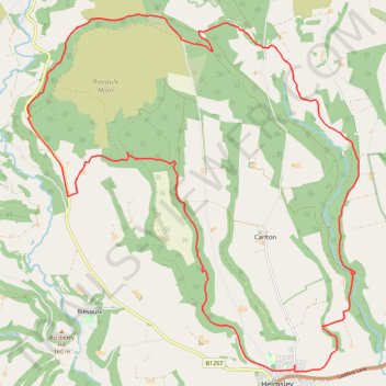
Helmsley Africa Loop
- Distance: 16.6 mi
- Elevation gain: 592 m
- Maximum elevation: 313 m
- Elevation loss: 592 m
- Minimum elevation: 56 m
- Moving time: 2 h 37 m
- Moving speed: 6.3 mph
- Maximum speed: 28.0 mph
- Total time: 3 h 14 m
- Global speed: 5.1 mph
Interactive trail map
Make a donation
Gear up for your next adventure:
As an Amazon Associate, this site earns from qualifying purchases at no extra cost to you.
Trail profile
- Distance: 16.6 mi
- Elevation gain: 592 m
- Maximum elevation: 313 m
- Elevation loss: 592 m
- Minimum elevation: 56 m
- Moving time: 2 h 37 m
- Moving speed: 6.3 mph
- Maximum speed: 28.0 mph
- Total time: 3 h 14 m
- Global speed: 5.1 mph
Make a donation
Gear up for your next adventure:
As an Amazon Associate, this site earns from qualifying purchases at no extra cost to you.
About this trail
Name: Helmsley Africa Loop trail, distance, elevation, map, profile, GPS track
Coordinates: 54.24817 -1.13493 54.30977 -1.03702
Topography: North Yorkshire topographic map, elevation, terrain
Make a donation
Gear up for your next adventure:
As an Amazon Associate, this site earns from qualifying purchases at no extra cost to you.
Other hiking, mountain biking, running and outdoor activity trails
Click on a trail to view its statistics, map and profile.
Ryedale Trail Running
United Kingdom > England > North Yorkshire
Malton to Helmsley trot. #Running #Nature #Forest #Countryside
Distance: 18.6 mi • Elevation gain: 430 m • Maximum elevation: 117 m
St Gregory's loop
United Kingdom > England > North Yorkshire > Helmsley
Distance: 19.0 mi • Elevation gain: 525 m • Maximum elevation: 294 m
Farndale
United Kingdom > England > North Yorkshire > Appleton-le-Moors
Ryedale Mountain Biking
Distance: 32.9 mi • Elevation gain: 1,251 m • Maximum elevation: 407 m