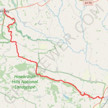
Ryedale Trail Running
Malton to Helmsley trot. #Running #Nature #Forest #Countryside
- Distance: 18.6 mi
- Elevation gain: 430 m
- Maximum elevation: 117 m
- Elevation loss: 393 m
- Minimum elevation: 23 m
- Moving time: 3 h 45 m
- Moving speed: 4.9 mph
- Maximum speed: 8.5 mph
- Total time: 3 h 49 m
- Global speed: 4.9 mph
Interactive trail map
Trail profile
- Distance: 18.6 mi
- Elevation gain: 430 m
- Maximum elevation: 117 m
- Elevation loss: 393 m
- Minimum elevation: 23 m
- Moving time: 3 h 45 m
- Moving speed: 4.9 mph
- Maximum speed: 8.5 mph
- Total time: 3 h 49 m
- Global speed: 4.9 mph
About this trail
Name: Ryedale Trail Running trail, distance, elevation, map, profile, GPS track
Coordinates: 54.12498 -1.05711 54.24854 -0.82105
Topography: North Yorkshire topographic map, elevation, terrain
Other hiking, mountain biking, running and outdoor activity trails
Click on a trail to view its statistics, map and profile.
Appleton piggies
United Kingdom > England > North Yorkshire > Norton-on-Derwent
Distance: 23.4 mi • Elevation gain: 512 m • Maximum elevation: 117 m
Derwent Kennythorpe Loop
United Kingdom > England > North Yorkshire > Norton-on-Derwent
Distance: 9.9 mi • Elevation gain: 193 m • Maximum elevation: 99 m
Helmsley Africa Loop
United Kingdom > England > North Yorkshire > Helmsley
Distance: 16.6 mi • Elevation gain: 592 m • Maximum elevation: 313 m
Huttons Ambo loop
United Kingdom > England > North Yorkshire > Norton-on-Derwent
Distance: 6.5 mi • Elevation gain: 97 m • Maximum elevation: 56 m
St Gregory's loop
United Kingdom > England > North Yorkshire > Helmsley
Distance: 19.0 mi • Elevation gain: 525 m • Maximum elevation: 294 m
Kennythorpe loop
United Kingdom > England > North Yorkshire > Norton-on-Derwent
Distance: 9.8 mi • Elevation gain: 186 m • Maximum elevation: 99 m
Low Hutton loop
United Kingdom > England > North Yorkshire > Norton-on-Derwent
Distance: 6.7 mi • Elevation gain: 103 m • Maximum elevation: 56 m
Menethorpe loop
United Kingdom > England > North Yorkshire > Norton-on-Derwent
Distance: 8.1 mi • Elevation gain: 162 m • Maximum elevation: 96 m
Derwent loop
United Kingdom > England > North Yorkshire > Norton-on-Derwent
Distance: 12.4 mi • Elevation gain: 229 m • Maximum elevation: 96 m
Malton Loop
United Kingdom > England > North Yorkshire > Norton-on-Derwent
Distance: 7.8 mi • Elevation gain: 119 m • Maximum elevation: 78 m
Hutton loop
United Kingdom > England > North Yorkshire > Norton-on-Derwent
Distance: 7.8 mi • Elevation gain: 90 m • Maximum elevation: 56 m