Thank you for supporting this site ❤️
Make a donation
Make a donation
Gear up for your next adventure:
As an Amazon Associate, this site earns from qualifying purchases at no extra cost to you.
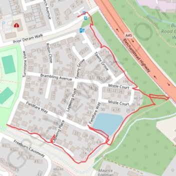
Canley footpath
- Distance: 0.6 mi
- Elevation gain: 3 m
- Maximum elevation: 93 m
- Elevation loss: 4 m
- Minimum elevation: 89 m
- Moving time: 14 m 53 s
- Moving speed: 2.5 mph
- Maximum speed: 3.7 mph
- Total time: 21 m 49 s
- Global speed: 1.7 mph
Interactive trail map
Thank you for supporting this site ❤️
Make a donation
Make a donation
Gear up for your next adventure:
As an Amazon Associate, this site earns from qualifying purchases at no extra cost to you.
Trail profile
- Distance: 0.6 mi
- Elevation gain: 3 m
- Maximum elevation: 93 m
- Elevation loss: 4 m
- Minimum elevation: 89 m
- Moving time: 14 m 53 s
- Moving speed: 2.5 mph
- Maximum speed: 3.7 mph
- Total time: 21 m 49 s
- Global speed: 1.7 mph
Thank you for supporting this site ❤️
Make a donation
Make a donation
Gear up for your next adventure:
As an Amazon Associate, this site earns from qualifying purchases at no extra cost to you.
About this trail
Name: Canley footpath trail, distance, elevation, map, profile, GPS track
Coordinates: 52.39230 -1.55815 52.39525 -1.55294
Topography: Coventry topographic map, elevation, terrain
Thank you for supporting this site ❤️
Make a donation
Make a donation
Gear up for your next adventure:
As an Amazon Associate, this site earns from qualifying purchases at no extra cost to you.
Other hiking, mountain biking, running and outdoor activity trails
Click on a trail to view its statistics, map and profile.
The Great Coventry Foodbankathon 2025
United Kingdom > England > Coventry
Distance: 20.3 mi • Elevation gain: 226 m • Maximum elevation: 121 m