Thank you for supporting this site ❤️
Make a donation
Make a donation
Gear up for your next adventure:
As an Amazon Associate, this site earns from qualifying purchases at no extra cost to you.
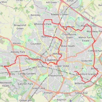
The Great Coventry Foodbankathon 2025
- Distance: 20.3 mi
- Elevation gain: 226 m
- Maximum elevation: 121 m
- Elevation loss: 201 m
- Minimum elevation: 66 m
Interactive trail map
Thank you for supporting this site ❤️
Make a donation
Make a donation
Gear up for your next adventure:
As an Amazon Associate, this site earns from qualifying purchases at no extra cost to you.
Trail profile
- Distance: 20.3 mi
- Elevation gain: 226 m
- Maximum elevation: 121 m
- Elevation loss: 201 m
- Minimum elevation: 66 m
Thank you for supporting this site ❤️
Make a donation
Make a donation
Gear up for your next adventure:
As an Amazon Associate, this site earns from qualifying purchases at no extra cost to you.
About this trail
Name: The Great Coventry Foodbankathon 2025 trail, distance, elevation, map, profile, GPS track
Coordinates: 52.38698 -1.58290 52.44592 -1.43862
Topography: Coventry topographic map, elevation, terrain
Thank you for supporting this site ❤️
Make a donation
Make a donation
Gear up for your next adventure:
As an Amazon Associate, this site earns from qualifying purchases at no extra cost to you.
Other hiking, mountain biking, running and outdoor activity trails
Click on a trail to view its statistics, map and profile.
Canley footpath
United Kingdom > England > Coventry
Distance: 0.6 mi • Elevation gain: 3 m • Maximum elevation: 93 m