
Danville Mountain Trail (Upper Loop, Extended) in Ouachita National Forest
- Distance: 2.7 mi
- Elevation gain: 146 m
- Maximum elevation: 326 m
- Elevation loss: 146 m
- Minimum elevation: 189 m
- Moving time: 40 m 40 s
- Moving speed: 4.0 mph
- Maximum speed: 7.7 mph
- Total time: 40 m 40 s
- Global speed: 4.0 mph
Interactive trail map
Trail profile
- Distance: 2.7 mi
- Elevation gain: 146 m
- Maximum elevation: 326 m
- Elevation loss: 146 m
- Minimum elevation: 189 m
- Moving time: 40 m 40 s
- Moving speed: 4.0 mph
- Maximum speed: 7.7 mph
- Total time: 40 m 40 s
- Global speed: 4.0 mph
About this trail
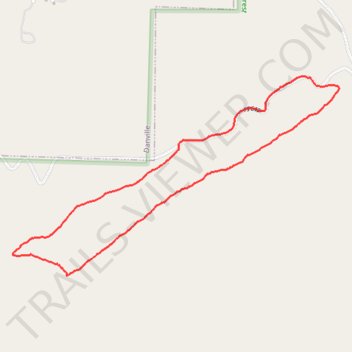
Name: Danville Mountain Trail (Upper Loop, Extended) in Ouachita National Forest trail, distance, elevation, map, profile, GPS track
Start: FS 649, Danville, Yell County, Arkansas, 72833, United States (35.04004 -93.37387)
End: FS 649, Danville, Yell County, Arkansas, 72833, United States (35.04004 -93.37387)
Coordinates: 35.03369 -93.38360 35.04320 -93.36461
Other hiking, mountain biking, running and outdoor activity trails
Click on a trail to view its statistics, map and profile.
Danville Mountain Trail (Lower Section) in Ouachita National Forest
United States > Arkansas > Yell County > Danville
Distance: 1.3 mi • Elevation gain: 118 m • Maximum elevation: 225 m