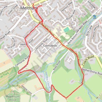
Meltham Walkers Are Welcome (South-East)
Interactive trail map
Trail profile
- Distance: 1.8 mi
- Elevation gain: 79 m
- Maximum elevation: 229 m
- Elevation loss: 79 m
- Minimum elevation: 177 m
- Moving time: 59 m 4 s
- Moving speed: 1.8 mph
- Maximum speed: 4.1 mph
- Total time: 1 h 7 m
- Global speed: 1.6 mph
About this trail
Name: Meltham Walkers Are Welcome (South-East) trail, distance, elevation, map, profile, GPS track
Coordinates: 53.58369 -1.85213 53.59222 -1.84212
Topography: Kirklees topographic map, elevation, terrain
Other hiking, mountain biking, running and outdoor activity trails
Click on a trail to view its statistics, map and profile.
Orchids in Honley wood and Wood Nook
United Kingdom > England > Kirklees > Meltham
Distance: 4.3 mi • Elevation gain: 156 m • Maximum elevation: 238 m
Meltham Mills Reservoir
United Kingdom > England > Kirklees > Meltham
Distance: 2.5 mi • Elevation gain: 76 m • Maximum elevation: 199 m