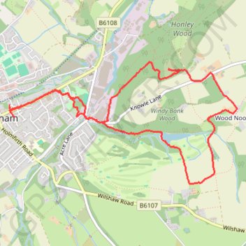
Orchids in Honley wood and Wood Nook
- Distance: 4.3 mi
- Elevation gain: 156 m
- Maximum elevation: 238 m
- Elevation loss: 160 m
- Minimum elevation: 156 m
- Moving time: 2 h 2 m
- Moving speed: 2.1 mph
- Maximum speed: 3.7 mph
- Total time: 2 h 29 m
- Global speed: 1.7 mph
Interactive trail map
Trail profile
- Distance: 4.3 mi
- Elevation gain: 156 m
- Maximum elevation: 238 m
- Elevation loss: 160 m
- Minimum elevation: 156 m
- Moving time: 2 h 2 m
- Moving speed: 2.1 mph
- Maximum speed: 3.7 mph
- Total time: 2 h 29 m
- Global speed: 1.7 mph
About this trail
Name: Orchids in Honley wood and Wood Nook trail, distance, elevation, map, profile, GPS track
Coordinates: 53.58649 -1.84893 53.59637 -1.81770
Topography: Kirklees topographic map, elevation, terrain
Other hiking, mountain biking, running and outdoor activity trails
Click on a trail to view its statistics, map and profile.
Hall Heys Wood
United Kingdom > England > Kirklees > Meltham
Loop hike from Meltham to the Hall Heys Wood by the Meltham Greenway. #Hiking #Loop #Forest #Nature #Countryside
Distance: 2.2 mi • Elevation gain: 79 m • Maximum elevation: 221 m
Honley woods and Wood Nook
United Kingdom > England > Kirklees > Meltham
Distance: 2.3 mi • Elevation gain: 62 m • Maximum elevation: 237 m
Meltham Mills Reservoir
United Kingdom > England > Kirklees > Meltham
Distance: 2.5 mi • Elevation gain: 76 m • Maximum elevation: 199 m