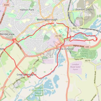
Wellingborough Waendel Walk walk
- Distance: 10.1 mi
- Elevation gain: 141 m
- Maximum elevation: 102 m
- Elevation loss: 139 m
- Minimum elevation: 38 m
- Moving time: 3 h 53 m
- Moving speed: 2.6 mph
- Maximum speed: 6.2 mph
- Total time: 4 h 39 m
- Global speed: 2.2 mph
Interactive trail map
Trail profile
- Distance: 10.1 mi
- Elevation gain: 141 m
- Maximum elevation: 102 m
- Elevation loss: 139 m
- Minimum elevation: 38 m
- Moving time: 3 h 53 m
- Moving speed: 2.6 mph
- Maximum speed: 6.2 mph
- Total time: 4 h 39 m
- Global speed: 2.2 mph
About this trail
Name: Wellingborough Waendel Walk walk trail, distance, elevation, map, profile, GPS track
Coordinates: 52.27248 -0.72892 52.30025 -0.65300
Topography: North Northamptonshire topographic map, elevation, terrain
Other hiking, mountain biking, running and outdoor activity trails
Click on a trail to view its statistics, map and profile.
Loop walk along River Nene around Chester House area
United Kingdom > England > North Northamptonshire > Little Irchester
Distance: 1.1 mi • Elevation gain: 8 m • Maximum elevation: 47 m
Walking from Kettering to Northampton via various PRoW paths
United Kingdom > England > North Northamptonshire > Kettering
Distance: 17.1 mi • Elevation gain: 267 m • Maximum elevation: 117 m
42 Km walk around Wellingborough
United Kingdom > England > North Northamptonshire > Wellingborough > Little Irchester
Distance: 25.9 mi • Elevation gain: 308 m • Maximum elevation: 115 m
The Jo Cox Way 2022 Day 3 Market Bosworth to Milton Keynes
United Kingdom > England > Leicestershire > Hinckley and Bosworth > Market Bosworth
Distance: 76.4 mi • Elevation gain: 953 m • Maximum elevation: 195 m