Import a GPX file

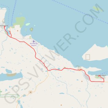
Port McNeill - Port Hardy

Vancouver Island. #Bike #McNeill #Hardy #Vancouver

  • Distance: 31.3 mi
  • Elevation gain: 472 m
  • Maximum elevation: 120 m
  • Elevation loss: 495 m
  • Minimum elevation: 1 m

Interactive trail map

Trail profile

  • Distance: 31.3 mi
  • Elevation gain: 472 m
  • Maximum elevation: 120 m
  • Elevation loss: 495 m
  • Minimum elevation: 1 m

About this trail

Other hiking, mountain biking, running and outdoor activity trails

Click on a trail to view its statistics, map and profile.

Dakota 576 Crash Site

Canada > British Columbia > Regional District of Mount Waddington > Port Hardy

Vancouver Island. #Hiking #Vancouver

Distance: 2.5 mi • Elevation gain: 134 m • Maximum elevation: 91 m

Gear up for your next adventure:

📸Action Camera Chest Mounts - Record your ascent following topographic paths hands-free
🧣Neck Gaiters - Versatile protection against wind and cold
🥾Trekking Poles - Poles to improve stability on uneven terrain
🧤Thermal Touchscreen Gloves - Stay warm while operating your GPS or smartphone camera
🎒Multi-day Trekking Packs - Large capacity backpacks for wild camping and long-distance trails

As an Amazon Associate, this site earns from qualifying purchases at no extra cost to you.