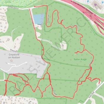
Taxter Ridge Loop Trails
- Distance: 5.1 mi
- Elevation gain: 186 m
- Maximum elevation: 158 m
- Elevation loss: 185 m
- Minimum elevation: 53 m
- Moving time: 1 h 38 m
- Moving speed: 3.1 mph
- Maximum speed: 10.4 mph
- Total time: 1 h 44 m
- Global speed: 2.9 mph
Interactive trail map
Trail profile
- Distance: 5.1 mi
- Elevation gain: 186 m
- Maximum elevation: 158 m
- Elevation loss: 185 m
- Minimum elevation: 53 m
- Moving time: 1 h 38 m
- Moving speed: 3.1 mph
- Maximum speed: 10.4 mph
- Total time: 1 h 44 m
- Global speed: 2.9 mph
About this trail
Name: Taxter Ridge Loop Trails trail, distance, elevation, map, profile, GPS track
Coordinates: 41.05018 -73.84968 41.05963 -73.83678
Other hiking, mountain biking, running and outdoor activity trails
Click on a trail to view its statistics, map and profile.