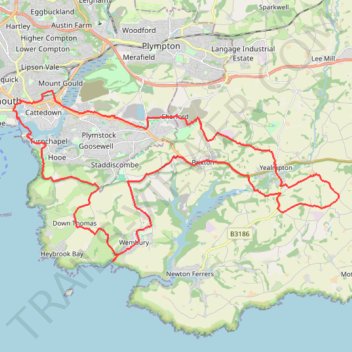
Plymouth eBike ride
- Distance: 26.9 mi
- Elevation gain: 798 m
- Maximum elevation: 116 m
- Elevation loss: 798 m
- Minimum elevation: 0 m
- Moving time: 2 h 32 m
- Moving speed: 10.6 mph
- Maximum speed: 33.2 mph
- Total time: 2 h 50 m
- Global speed: 9.5 mph
Interactive trail map
Trail profile
- Distance: 26.9 mi
- Elevation gain: 798 m
- Maximum elevation: 116 m
- Elevation loss: 798 m
- Minimum elevation: 0 m
- Moving time: 2 h 32 m
- Moving speed: 10.6 mph
- Maximum speed: 33.2 mph
- Total time: 2 h 50 m
- Global speed: 9.5 mph
About this trail
Name: Plymouth eBike ride trail, distance, elevation, map, profile, GPS track
Start: Lucas Terrace, Mount Gould, Plymouth, England, PL4 9HG, United Kingdom (50.37450 -4.11548)
End: 54, Lanhydrock Road, Mount Gould, Plymouth, England, PL4 9HQ, United Kingdom (50.37458 -4.11533)
Coordinates: 50.31764 -4.13598 50.37460 -3.96539
Topography: Plymouth topographic map, elevation, terrain
Other hiking, mountain biking, running and outdoor activity trails
Click on a trail to view its statistics, map and profile.
Loop from Wembury in South Devon National Landscape
United Kingdom > England > Devon > South Hams > Wembury
Distance: 13.3 mi • Elevation gain: 640 m • Maximum elevation: 117 m
Saltram, Chelson Meadow, Prince Rock, Tothill
United Kingdom > England > Plymouth > Plympton
Distance: 9.8 mi • Elevation gain: 189 m • Maximum elevation: 33 m
Wembury ebike ride
United Kingdom > England > Devon > South Hams > Wembury
Distance: 4.5 mi • Elevation gain: 174 m • Maximum elevation: 111 m
Mountbatten, Down Thomas
United Kingdom > England > Plymouth
Distance: 8.8 mi • Elevation gain: 386 m • Maximum elevation: 114 m