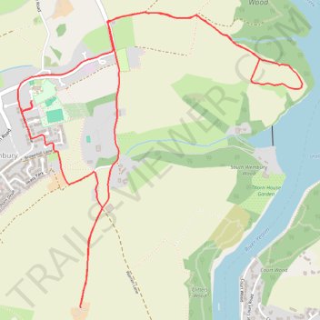
Wembury ebike ride
- Distance: 4.5 mi
- Elevation gain: 174 m
- Maximum elevation: 111 m
- Elevation loss: 175 m
- Minimum elevation: 20 m
- Moving time: 39 m 10 s
- Moving speed: 6.9 mph
- Maximum speed: 24.0 mph
- Total time: 43 m 59 s
- Global speed: 6.2 mph
Interactive trail map
Trail profile
- Distance: 4.5 mi
- Elevation gain: 174 m
- Maximum elevation: 111 m
- Elevation loss: 175 m
- Minimum elevation: 20 m
- Moving time: 39 m 10 s
- Moving speed: 6.9 mph
- Maximum speed: 24.0 mph
- Total time: 43 m 59 s
- Global speed: 6.2 mph
About this trail
Name: Wembury ebike ride trail, distance, elevation, map, profile, GPS track
Coordinates: 50.31604 -4.07137 50.33161 -4.04795
Topography: South Hams topographic map, elevation, terrain
Other hiking, mountain biking, running and outdoor activity trails
Click on a trail to view its statistics, map and profile.
Loop from Wembury in South Devon National Landscape
United Kingdom > England > Devon > South Hams > Wembury
Distance: 13.3 mi • Elevation gain: 640 m • Maximum elevation: 117 m
Plymouth eBike ride
United Kingdom > England > Plymouth
Distance: 26.9 mi • Elevation gain: 798 m • Maximum elevation: 116 m