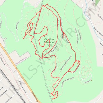
Port Jervis Watershed / Elks-Brox Memorial Park
- Distance: 4.0 mi
- Elevation gain: 162 m
- Maximum elevation: 289 m
- Elevation loss: 160 m
- Minimum elevation: 213 m
- Moving time: 1 h 16 m
- Moving speed: 3.2 mph
- Maximum speed: 5.5 mph
- Total time: 1 h 25 m
- Global speed: 2.8 mph
Interactive trail map
Trail profile
- Distance: 4.0 mi
- Elevation gain: 162 m
- Maximum elevation: 289 m
- Elevation loss: 160 m
- Minimum elevation: 213 m
- Moving time: 1 h 16 m
- Moving speed: 3.2 mph
- Maximum speed: 5.5 mph
- Total time: 1 h 25 m
- Global speed: 2.8 mph
About this trail
Name: Port Jervis Watershed / Elks-Brox Memorial Park trail, distance, elevation, map, profile, GPS track
Coordinates: 41.37957 -74.69957 41.38914 -74.69197
Other hiking, mountain biking, running and outdoor activity trails
Click on a trail to view its statistics, map and profile.
Port Jervis Watershed
United States > New York > Orange County
Distance: 29.3 mi • Elevation gain: 919 m • Maximum elevation: 343 m