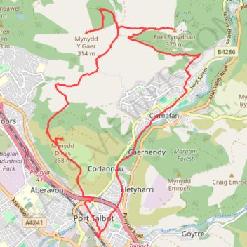
Mynydd Dinas, Mynydd Y Gaer and Foel Fynyddau Loop Walk
- Distance: 11.3 mi
- Elevation gain: 617 m
- Maximum elevation: 370 m
- Elevation loss: 617 m
- Minimum elevation: 7 m
- Moving time: 4 h 38 m
- Moving speed: 2.4 mph
- Maximum speed: 7.3 mph
- Total time: 5 h 12 m
- Global speed: 2.2 mph
Interactive trail map
Trail profile
- Distance: 11.3 mi
- Elevation gain: 617 m
- Maximum elevation: 370 m
- Elevation loss: 617 m
- Minimum elevation: 7 m
- Moving time: 4 h 38 m
- Moving speed: 2.4 mph
- Maximum speed: 7.3 mph
- Total time: 5 h 12 m
- Global speed: 2.2 mph
About this trail
Name: Mynydd Dinas, Mynydd Y Gaer and Foel Fynyddau Loop Walk trail, distance, elevation, map, profile, GPS track
Coordinates: 51.59176 -3.79551 51.63149 -3.75239
Topography: Neath Port Talbot topographic map, elevation, terrain
Other hiking, mountain biking, running and outdoor activity trails
Click on a trail to view its statistics, map and profile.
The Headstock 500
United Kingdom > Wales > Newport > Newport
Distance: 300.4 mi • Elevation gain: 9,616 m • Maximum elevation: 691 m