Walkley Heights Reserve
- Distance: 4.5 mi
- Elevation gain: 93 m
- Maximum elevation: 96 m
- Elevation loss: 91 m
- Minimum elevation: 53 m
- Moving time: 1 h 36 m
- Moving speed: 2.8 mph
- Maximum speed: 6.2 mph
- Total time: 1 h 40 m
- Global speed: 2.7 mph
Interactive trail map
Trail profile
- Distance: 4.5 mi
- Elevation gain: 93 m
- Maximum elevation: 96 m
- Elevation loss: 91 m
- Minimum elevation: 53 m
- Moving time: 1 h 36 m
- Moving speed: 2.8 mph
- Maximum speed: 6.2 mph
- Total time: 1 h 40 m
- Global speed: 2.7 mph
About this trail
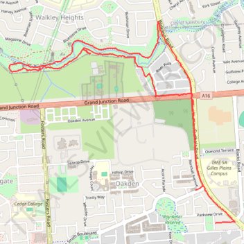
Name: Walkley Heights Reserve trail, distance, elevation, map, profile, GPS track
Coordinates: -34.85583 138.63231 -34.84041 138.65332
Other hiking, mountain biking, running and outdoor activity trails
Click on a trail to view its statistics, map and profile.
Walkley Heights Reserve
Australia > South Australia > Adelaide
Distance: 2.9 mi • Elevation gain: 65 m • Maximum elevation: 73 m
Dry Creek Trail
Australia > South Australia > Adelaide
Distance: 14.0 mi • Elevation gain: 263 m • Maximum elevation: 204 m