Make a donation
Gear up for your next adventure:
As an Amazon Associate, this site earns from qualifying purchases at no extra cost to you.
Walkley Heights Reserve
- Distance: 2.9 mi
- Elevation gain: 65 m
- Maximum elevation: 73 m
- Elevation loss: 64 m
- Minimum elevation: 50 m
- Moving time: 55 m 39 s
- Moving speed: 3.1 mph
- Maximum speed: 5.3 mph
- Total time: 1 h 5 m
- Global speed: 2.6 mph
Interactive trail map
Make a donation
Gear up for your next adventure:
As an Amazon Associate, this site earns from qualifying purchases at no extra cost to you.
Trail profile
- Distance: 2.9 mi
- Elevation gain: 65 m
- Maximum elevation: 73 m
- Elevation loss: 64 m
- Minimum elevation: 50 m
- Moving time: 55 m 39 s
- Moving speed: 3.1 mph
- Maximum speed: 5.3 mph
- Total time: 1 h 5 m
- Global speed: 2.6 mph
Make a donation
Gear up for your next adventure:
As an Amazon Associate, this site earns from qualifying purchases at no extra cost to you.
About this trail
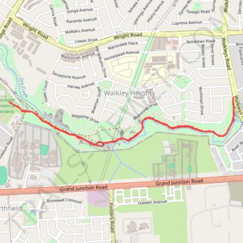
Name: Walkley Heights Reserve trail, distance, elevation, map, profile, GPS track
Coordinates: -34.84397 138.62649 -34.84039 138.64619
Make a donation
Gear up for your next adventure:
As an Amazon Associate, this site earns from qualifying purchases at no extra cost to you.
Other hiking, mountain biking, running and outdoor activity trails
Click on a trail to view its statistics, map and profile.
Walkley Heights Reserve
Australia > South Australia > Adelaide
Distance: 4.5 mi • Elevation gain: 93 m • Maximum elevation: 96 m
Dry Creek Trail
Australia > South Australia > Adelaide
Distance: 14.0 mi • Elevation gain: 263 m • Maximum elevation: 204 m