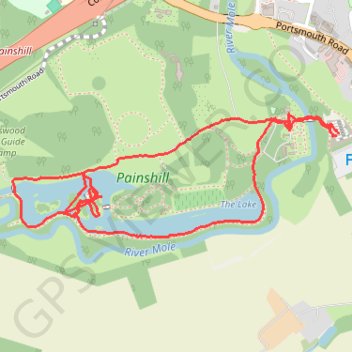
Painshill Loop
Interactive trail map
Trail profile
- Distance: 2.3 mi
- Elevation gain: 29 m
- Maximum elevation: 33 m
- Elevation loss: 29 m
- Minimum elevation: 15 m
About this trail
Name: Painshill Loop trail, distance, elevation, map, profile, GPS track
Start: Cobham, Elmbridge, Surrey, England, KT11 1AG, United Kingdom (51.33002 -0.41917)
End: Cobham, Elmbridge, Surrey, England, KT11 1AG, United Kingdom (51.33007 -0.41906)
Coordinates: 51.32711 -0.43395 51.33062 -0.41906
Topography: Elmbridge topographic map, elevation, terrain