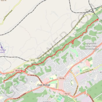
North Ridge Trail from Endicott Lane to West Outer Drive in Oak Ridge Tennessee
Hike
- Distance: 7.5 mi
- Elevation gain: 443 m
- Maximum elevation: 353 m
- Elevation loss: 440 m
- Minimum elevation: 272 m
- Moving time: 3 h 12 m
- Moving speed: 2.3 mph
- Maximum speed: 3.4 mph
- Total time: 3 h 21 m
- Global speed: 2.2 mph
Interactive trail map
Trail profile
- Distance: 7.5 mi
- Elevation gain: 443 m
- Maximum elevation: 353 m
- Elevation loss: 440 m
- Minimum elevation: 272 m
- Moving time: 3 h 12 m
- Moving speed: 2.3 mph
- Maximum speed: 3.4 mph
- Total time: 3 h 21 m
- Global speed: 2.2 mph
About this trail
Name: North Ridge Trail from Endicott Lane to West Outer Drive in Oak Ridge Tennessee trail, distance, elevation, map, profile, GPS track
Coordinates: 36.01162 -84.30550 36.05813 -84.22088
Other hiking, mountain biking, running and outdoor activity trails
Click on a trail to view its statistics, map and profile.
North Ridge Segment From Run
United States > Tennessee > Anderson County > Oak Ridge > Robertsville
Stretching Required
Distance: 5.2 mi • Elevation gain: 173 m • Maximum elevation: 345 m