North Ridge Segment From Run
Stretching Required
- Distance: 5.2 mi
- Elevation gain: 173 m
- Maximum elevation: 345 m
- Elevation loss: 172 m
- Minimum elevation: 258 m
- Moving time: 48 m 28 s
- Moving speed: 6.5 mph
- Maximum speed: 11.7 mph
- Total time: 52 m 16 s
- Global speed: 6.0 mph
Interactive trail map
Trail profile
- Distance: 5.2 mi
- Elevation gain: 173 m
- Maximum elevation: 345 m
- Elevation loss: 172 m
- Minimum elevation: 258 m
- Moving time: 48 m 28 s
- Moving speed: 6.5 mph
- Maximum speed: 11.7 mph
- Total time: 52 m 16 s
- Global speed: 6.0 mph
About this trail
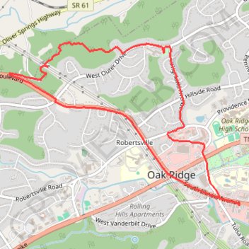
Name: North Ridge Segment From Run trail, distance, elevation, map, profile, GPS track
Coordinates: 36.00708 -84.29038 36.02395 -84.26092
Other hiking, mountain biking, running and outdoor activity trails
Click on a trail to view its statistics, map and profile.
North Ridge Trail from Endicott Lane to West Outer Drive in Oak Ridge Tennessee
United States > Tennessee > Anderson County > Oak Ridge
Hike
Distance: 7.5 mi • Elevation gain: 443 m • Maximum elevation: 353 m