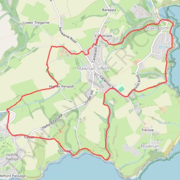
Mawnan Smith Loop
- Distance: 6.6 mi
- Elevation gain: 263 m
- Maximum elevation: 79 m
- Elevation loss: 262 m
- Minimum elevation: 2 m
- Moving time: 1 h 14 m
- Moving speed: 5.3 mph
- Maximum speed: 9.8 mph
- Total time: 1 h 16 m
- Global speed: 5.2 mph
Interactive trail map
Trail profile
- Distance: 6.6 mi
- Elevation gain: 263 m
- Maximum elevation: 79 m
- Elevation loss: 262 m
- Minimum elevation: 2 m
- Moving time: 1 h 14 m
- Moving speed: 5.3 mph
- Maximum speed: 9.8 mph
- Total time: 1 h 16 m
- Global speed: 5.2 mph
About this trail
Name: Mawnan Smith Loop trail, distance, elevation, map, profile, GPS track
Coordinates: 50.10262 -5.13036 50.12438 -5.09006
Topography: Cornwall topographic map, elevation, terrain
Other hiking, mountain biking, running and outdoor activity trails
Click on a trail to view its statistics, map and profile.
Mawnan Helford loop
United Kingdom > England > Cornwall > Falmouth > Carlidnack
Distance: 7.2 mi • Elevation gain: 281 m • Maximum elevation: 97 m
Durgan to Mawnan walk
United Kingdom > England > Cornwall > Mawnan Smith
Distance: 2.1 mi • Elevation gain: 112 m • Maximum elevation: 59 m
Mawnan Smith loop
United Kingdom > England > Cornwall > Falmouth > Bareppa
Cornwall Road Cycling
Distance: 34.1 mi • Elevation gain: 926 m • Maximum elevation: 202 m