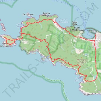
PORQUEROLLES
- Distance: 8.0 mi
- Elevation gain: 298 m
- Maximum elevation: 91 m
- Elevation loss: 296 m
- Minimum elevation: 0 m
- Moving time: 4 h 16 m
- Moving speed: 1.9 mph
- Maximum speed: 2.1 mph
- Total time: 4 h 16 m
- Global speed: 1.9 mph
Interactive trail map
Trail profile
- Distance: 8.0 mi
- Elevation gain: 298 m
- Maximum elevation: 91 m
- Elevation loss: 296 m
- Minimum elevation: 0 m
- Moving time: 4 h 16 m
- Moving speed: 1.9 mph
- Maximum speed: 2.1 mph
- Total time: 4 h 16 m
- Global speed: 1.9 mph
About this trail
Name: PORQUEROLLES trail, distance, elevation, map, profile, GPS track
Coordinates: 42.98649 6.16166 43.00707 6.20378
Other hiking, mountain biking, running and outdoor activity trails
Click on a trail to view its statistics, map and profile.
1 LUCENA - MONTPELLIER
Distance: 1,842.0 mi • Elevation gain: 29,500 m • Maximum elevation: 1,048 m
PT23DS2 Lörrach → Cadaqués
Germany > Baden-Württemberg > Landkreis Lörrach > Lörrach (Kernstadt)
Distance: 652.9 mi • Elevation gain: 13,130 m • Maximum elevation: 1,505 m